
A saved list is a starting point
The full route explains the overfull transfers, permit-dependent hikes and alternatives. Leave room for the return, parking and the next overnight.
Read every day →These are the actual places saved in the starting route, including conditional and optional choices. Read the complete daily plan before treating the list as a schedule.
Explore the choices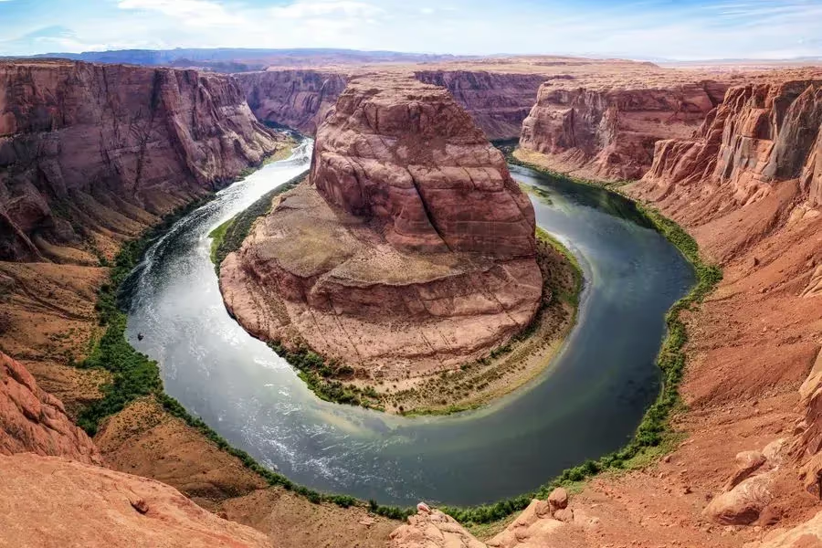
Make the trip fit you
The full route explains the overfull transfers, permit-dependent hikes and alternatives. Leave room for the return, parking and the next overnight.
Read every day →Source groups include wider areas. A Bluff stay is not at Monument Valley, an Escalante stay is not beside Bryce, and a Grand Canyon Junction stay is outside the national park.
EXPLORE THE MAP
Browse the visit guides, or open the map to compare locations.

Valley of Fire is in Nevada, on the gateway side of the road trip. Choose it only when arrival time, heat and the onward Zion transfer leave enough room.
Open visit guide Photo by Andrew Broderick Qdfx0
During shuttle operation, the Zion Canyon Scenic Drive is primarily a shuttle journey. Check the current schedule and permitted vehicle access before planning it as a private-car drive.
Open visit guide Photo by Feeltoep
A bottom-up Narrows outing starts from the Temple of Sinawava side when conditions allow. River flow, flash-flood risk, water quality and closures decide whether to enter.
Open visit guide Photo by Karan Chawla
Angels Landing is a permit-dependent, exposed ridge hike. Choose it for your group’s comfort with heights and leave another day for a long river outing.
Open visit guide Photo by Sapan Patel
Choose the currently accessible Emerald Pools route. Bridges and trail sections can close independently; a saved waterfall photo does not establish access.
Open visit guide Photo by Dulcey Lima
Choose Inspiration Point for the layered hoodoo view, then decide how far along the rim you want to walk. Do not assume the onward rim section is accessible in winter.
Open visit guide Photo by Yang Song
Treat the Figure Eight as the main Bryce walking day. Multiple connected trail sections make this a different commitment from a short viewpoint visit.
Open visit guide Photo by Anqi Lu
Choose Bryce Point for a broad amphitheater view. Combine it with another rim stop when the road is accessible, rather than adding another long descent.
Open visit guide Photo by Tobi 87
Use the southern scenic drive when you have time beyond the main amphitheater. It is a driving outing with stops, and winter storms can shorten the accessible road.
Open visit guide Photo by Tim Swinehart
A ranger-led full moon hike depends on the park’s actual program and reservation process. Keep your Bryce day worthwhile without assuming a place on the walk.
Open visit guide Photo by Ken Cheung
The Wave needs a Coyote Buttes North permit and a dedicated wilderness day. The BLM describes a strenuous 6.4-mile round trip requiring navigation; a short source allowance is not a complete plan.
Open visit guide Photo by Gert Boers
Lone Rock is across the Utah border from Page. Water levels and local access affect the shoreline experience; check the current approach rather than relying on a saved photo.
Open visit guide Photo by Osvaldo Urriola
Glen Canyon Dam is a Page-area stop. Distinguish a viewpoint visit from any interior program, and check which facilities are operating for your date.
Open visit guide Photo by John Gibbons
Book the exact Antelope Canyon tour you want. A guided visit is required, and Upper and Lower canyon departures have different meeting points and physical demands.
Open visit guide Photo by Martina Misar
Leave walking time and sun protection for Horseshoe Bend. It is an exposed approach to a rim viewpoint, not a pull-over photograph from the car.
Open visit guide Photo by Gert Boers
This gorge stop is on Navajo land along the eastern approach to the South Rim. Check tribal access rather than assuming a national-park pass covers the visit.
Open visit guide Photo by Pavel Špindler
Choose a manageable section of the South Rim Trail. The full trail is much longer than a quick overlook visit; match the walk to the actual return transport.
Open visit guide Photo by Josh Sorenson
South Kaibab is an exposed below-rim hike. Choose a turnaround that leaves a realistic climb out and verify transport, conditions and water arrangements.
Open visit guide Photo by Fabrizio Coco
Choose a sensible turnaround on Bright Angel before descending. The return is uphill, and a full river-and-back outing is not the default day-hike plan.
Open visit guide Photo by Jacob Jolibois
Mather Point is a South Rim viewpoint near the visitor-center area. Leave time for parking or shuttle connections before continuing to a rim walk.
Open visit guide Photo by Michael Quinn
Hoover Dam is a gateway-side detour on the return toward Las Vegas. A viewpoint stop and a booked interior tour require different amounts of time.
Open visit guide Photo by Cedric Dhaenens Ul
This saved helicopter excursion is a Nevada-side gateway option. Confirm the operator, departure location, route and check-in before tying it to a flight home.
Open visit guideLocations from Fyno’s curated places. Use current road and site guidance for access; pins are not a driving route.
No. The saved list contains alternatives and busy combinations. Read the route’s daily guidance and keep the stops that fit your group, permits and daylight.
Membership checked against the committed website catalog November 5, 2026. Regional stay alternatives are not selected nights or available rooms.