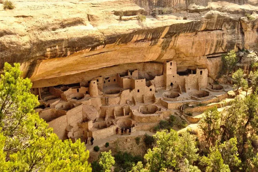
Adds Telluride, Ouray and Mesa Verde to the central loop. The source labels this eleven days but saves twelve day groups. The Monarch Lake hike and several cross-state transfers need their own review; the Old School Lodge overnight is near Montrose, not Telluride.
Seasonal roads change the loop
Trail Ridge Road and Independence Pass are seasonal connections. A source May–October label is not an opening calendar. Check the actual crossing and a paved alternative before booking the next overnight. [2][5][4]
Reserve the actual place
Rocky Mountain timed entry, Bear Lake Road access, Hanging Lake permits, Maroon Bells transport and Mesa Verde tours are different bookings. A park pass or hotel reservation does not replace them. Check the current season before fixing a route. [1][7][8][11]
EXPLORE THE MAP
Places to shape your trip
Browse the visit guides, or open the map to compare locations.
32 places
01 · Denver
Use City Park as a relaxed city block. Decide separately whether to add a museum or zoo visit; those need their own admission and time.
The source pin is the Congress Park taproom. Check the exact location and hours; use an evening after sightseeing instead of a timed stop before driving.
Mount Goliath belongs to the Mount Blue Sky approach, not central Denver. Check the road and access reservation that covers the part of the corridor you want.
Mount Evans is now named Mount Blue Sky. The canonical source URL remains unchanged. Check the seasonal CO-5 road and Recreation.gov requirements before planning the high-elevation drive.
11 · Indian Peaks Wilderness · Monarch Lake approach
This is a long wilderness hike, not an Estes Park walk. Colorado COTREX lists about 14.3 miles from Monarch Lake. Give it a full day and check USFS access and any overnight permit separately.
Make Emerald Lake your main walk rather than requiring both Emerald and Haiyaha before a long westbound transfer. Trail conditions and Bear Lake access matter.
Choose Haiyaha as an alternative to Emerald Lake when time is limited. Do not count the two as short roadside lake stops; allow for the shared approach and rocky terrain.
A through crossing depends on seasonal opening and conditions. It is a scenic transfer with stops; do not add two substantial Bear Lake hikes before driving on to Glenwood Springs.
Reserve Hanging Lake as the main walk for this block. The current official page requires a year-round timed permit and self-drive parking; it explicitly lists no shuttle.
Choose the Maroon Lake visit or a longer wilderness walk, then book the right access. The 2026 shuttle ran May 22–October 18; future dates need checking.
Choose a rim and check its roads and trails. Black Canyon is near Montrose, not in Telluride; current NPS conditions also flag fire-affected terrain on some South Rim trails.
Ouray is its own mountain town. Combine town time with a suitable local outing, or use it as the approach to the Million Dollar Highway; Telluride is a separate drive.
The Million Dollar Highway is a mountain drive between Ouray and Silverton. It does not connect directly through Telluride; allow separate driving and check conditions.
Give Ancestral Pueblo heritage the time it deserves. Choose overlooks or a specific ranger-led cliff dwelling tour; tours require their own reservation and seasonal access.
A short dune walk can be enough. Set the distance by sand temperature, wind and your return time rather than treating every ridge as a required summit.
High Dune is an effortful walk on soft sand. There is no fixed maintained loop across the dunes; choose a return route and turn-around time that fit the conditions.
Make the central rock formations the focus of a local walking block. Leave time to park and choose the actual trail; the Pikes Peak summit is a separate excursion.
Plan this as an eastern plains detour. Stay on designated trails and leave the formations untouched; do not pair its sunset with a rushed mountain summit return.
This is the route’s collection. Open the itinerary for all saved days, overnights and the day-specific feasibility notes.
Sources & planning notes
Fyno curation is the source for included places and saved route membership (cached October 27, 2026). Official planning sources checked November 5, 2026. 2026 reservation dates are historical season guidance, not a promise for 2027. Time allowances are editorial estimates, not live directions; map pins are places, not driving routes. Original attributed Expert tips remain on entity pages; current access notes take precedence where guidance differs.